
Loading...

GeoTech Design Consultants — Geotechnical & Geoenvironmental Engineering

Explore Our Solutions Get a Quote

Engineering-Led

In-house, site-specific design. Optimised for safety, cost and life.

Turnkey Delivery

Survey, design and build in one hand. Clear accountability, faster delivery.

Safety & Quality

Strict safety norms on every site. Documented QA/QC and material testing.

Technical Expertise

Qualified engineers and trained crews. Proven on complex, high-risk sites.

Modern Methods

Advanced equipment, certified materials. Sustainable, long-lasting results.

Nationwide Reach

Delivered on time and on budget. Projects across the country.
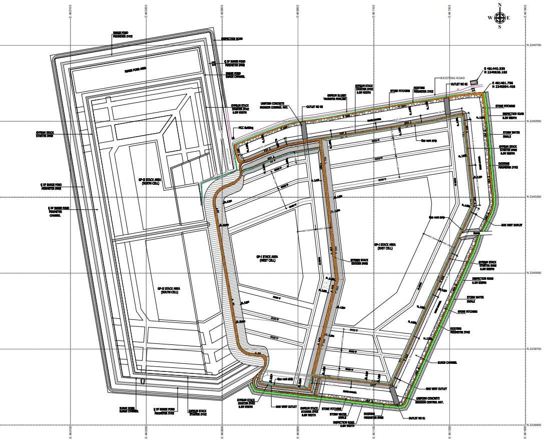
Engineering layout plan of a lined containment facility prepared by GeoTech Design Consultants
Study · Design · DeliverConsultancy arm of GeoTech Buildcon Pvt. Ltd.
Overview

Geotechnical & Geoenvironmental Engineering

GeoTech Design Consultants is a specialized engineering consultancy company, delivering innovative, sustainable, and technically advanced solutions in Infrastructure, geotechnical engineering, Civil & Environmental Engineering projects. We provide comprehensive consultancy services encompassing project planning, engineering design, project execution, project management advisory.

Our work is centered on understanding ground and slope conditions and turning them into practical, buildable solutions — from site investigation and feasibility studies to design, drawings and execution support, across rockfall / slope protection and geo-environmental facilities.

What We Do

Our Expertise

End-to-end engineering across our two verticals — Rockfall / Slope Protection and Geo-Environmental Engineering — from first site visit to long-term maintenance.

03

Project Execution

Engineering support that carries the design through to the ground, with construction delivered by GeoTech Buildcon Pvt. Ltd.

Learn more
04

Project Management Consultancy

Independent oversight of schedule, cost, quality and safety, from award through to handover.

Learn more
05

Annual Maintenance Contract

Scheduled inspection, monitoring and upkeep that keeps slopes, ponds and landfills performing safely for their full life.

Learn more

Our Services

Know More
Why GeoTech

The GeoTech Advantage

01

Engineering-Led

  • In-house, site-specific design
  • Optimised for safety, cost and life
02

Turnkey Delivery

  • Survey, design and build in one hand
  • Clear accountability, faster delivery
03

Safety & Quality

  • Strict safety norms on every site
  • Documented QA/QC and material testing
04

Technical Expertise

  • Qualified engineers and trained crews
  • Proven on complex, high-risk sites
05

Modern Methods

  • Advanced equipment, certified materials
  • Sustainable, long-lasting results
06

Nationwide Reach

  • Delivered on time and on budget
  • Projects across the country
Testimonials

What Our Clients Say

Industry teams across India trust us for practical engineering, clear deliverables and dependable coordination.

Geotech Design Consultants demonstrated excellent technical expertise and a practical approach to our project.

KS
Kedar Sharma

We appreciated the Geotech team, your engineering support and timely deliverables helped us move the project forward.

SF
Sanjay Fulzale

Thank you, GDC for everything. We truly thank you for your professional approach throughout the project.

SG
Swapnil Gupta

Working with Geotech Design Consultants was a very good experience. Your team combined strong engineering knowledge with effective coordination.

SS
Sandeep Singh

You provided excellent technical support and practical solutions, thank you!

AK
Abhishek Kadam
FAQ

Frequently Asked Questions

We are a specialized engineering consultancy delivering geotechnical and geo-environmental solutions — Rockfall / Slope Protection, and Geo-Environmental Engineering for ash dykes, ash ponds, slurry ponds, reservoirs and landfills — across the full project cycle.

We support the full project lifecycle — feasibility study and investigation, design and drawing, project execution support, Project Management Consultancy (PMC), and Annual Maintenance Contracts (AMC) after completion.

Yes — we are the engineering consultancy arm of GeoTech Buildcon Pvt. Ltd. This gives us deep technical expertise combined with real on-site construction experience, so our designs are practical and buildable, not just compliant on paper.

A Feasibility Study Report, Technical Assessment Report, Options and Alternative Solutions Assessment (where applicable), and a Risk Assessment — giving you an evidence-based basis for investment decisions before design begins.

Yes. Our Annual Maintenance Contracts (AMC) help keep completed slopes, ponds and landfills performing safely and reliably over their working life.

Get in touch through our Contact page with a brief description of your project. We'll follow up to understand your requirements and outline the right starting point — usually a feasibility study or site assessment.

Rockfall protection deals with blocks that detach and fall — mesh, netting, drapery and rockfall barriers that hold or intercept them. Slope protection deals with the stability of the slope mass itself — soil nailing, anchoring, retaining structures and drainage. Most hill sites need both, in different zones of the same face.

Mesh and drapery treat the face where blocks detach; a rockfall barrier stands away from the face and stops blocks already falling. The rockfall trajectory analysis decides which is right — and where a large source zone sits above the asset, both are usually specified together.

It comes out of the trajectory analysis: design block mass, fall height and slope profile give the impact energy and bounce height, and the barrier is selected above that with the required residual height. Choosing a class from a catalogue without the analysis is how barriers get overtopped.

To the ground actually present on the alignment — micropiles or drilled and grouted rock anchors sized for the post and rope reactions given by the barrier supplier, with an anchor test regime specified. Foundations, not the net, are where most rockfall barrier problems begin.

Soil nailing holds a cut that would otherwise slip — soil or weathered rock that has to stand steeper than its natural angle. A barrier does nothing for that; it only catches falling blocks. Where the face is jointed rock, nails give way to rock bolts and anchors.

Yes. The rockfall protection and slope protection feasibility study establishes what the slope is doing, which measures are practical and roughly what they will cost — before engineering spend is committed to a scheme that may not suit the site.

Geological mapping, rock mass characterisation and discontinuity surveys for rockfall; boreholes, trial pits, in-situ and laboratory testing and groundwater assessment for slope stability. The scope is set by the failure mechanisms suspected at survey stage, not by a standard package.

General arrangement and layout drawings, rockfall barrier drawings, mesh and netting details, soil nailing and anchoring details, drainage details, typical sections, construction details, design calculations, technical specifications, bill of quantities and tender documentation.

Cost per running metre rises with energy class, post height and foundation type — but on most hill sites access moves the figure more than the hardware does. Send the slope section and we will price the realistic options against each other rather than quote a rate blind.

It depends on the data in hand. With survey and investigation available, a single face is a matter of weeks; a corridor with many faces takes longer and is usually issued in packages. Tell us the programme and we will confirm dates against it.

IS 14458 for hill area protection works, IRC:SP:48 for hill roads, IS 1893 (Part 1) for the seismic case, ETAG 027 / EAD 340059 for type-tested rockfall barrier kits and FHWA GEC No. 7 for soil nail walls — with the design basis and parameters issued alongside every submission.

Both. Project execution support covers methodology review, site inspection, quality monitoring and design clarification; PMC adds full coordination, progress monitoring, measurement and handover. Site conditions vary from design assumptions, so review during construction matters.

Periodic inspection of rockfall barriers, mesh, anchors, rock bolts, drainage and retaining structures — checking accumulation, damage, corrosion, blockage, erosion, cracking and signs of renewed instability. Frequency is set by exposure and hazard; hill corridors are usually inspected after each monsoon.

Yes. Geotech Design Consultants provides rockfall protection and slope stabilization consultancy in Mumbai, covering the complete cycle — survey, geotechnical investigation, design and drawings, execution support, PMC and AMC.

Yes. We provide rockfall protection and slope protection consultancy across India, and clients engage us at whichever stage the project has reached — from feasibility study to annual maintenance.

Geo-environmental engineering is the branch of geotechnical engineering that deals with storing or containing material that must not escape — ash, slurry, tailings, water or waste. In practice that means ash dyke and ash pond design, slurry pond and tailings pond design, raw water and process reservoirs, and engineered landfills, together with the liners, drainage, monitoring and closure works that go with them.

The ash pond is the storage area that holds the ash and the supernatant water; the ash dyke is the embankment that forms it. They are designed together: the pond fixes the storage volume and water level, and the ash dyke has to be stable against that level for every stage of raising, through the monsoon and under seismic loading.

Storage follows from ash generation, the fly ash and bottom ash split, the mode of disposal and the in-pond dry density achieved — not from area alone. We build a capacity–elevation curve for the site and then fix the number of raising stages so that each stage buys a sensible number of years of storage. Too few stages lock up capital and land early; too many spend the saving on repeated mobilisation and interim drainage.

Upstream raising is the cheapest in fill and land but places the new dyke over deposited ash, so it is only acceptable where that ash is drained, strong enough and not liquefiable. Downstream raising is the safest and takes the most land and fill. Centreline raising is the compromise. The choice is made from piezocone and strength testing through the deposited ash and from the seismic zone — not from cost alone.

It depends on the ground, the groundwater and the regulator. Where the sub-soil is permeable or the water table is shallow and in use, a lining system — compacted clay, amended soil or a geomembrane — is required, and the SPCB usually sets the standard as a condition of consent. Where natural low-permeability strata exist and can be proved by field permeability testing, lining requirements can be reduced. The investigation, not an assumption, settles it.

Boreholes with SPT and undisturbed sampling along the dyke alignment and over the pond area, CPT or piezocone where soft strata are suspected, geophysics to bracket rock level, trial pits and testing in every borrow area, field permeability and density, piezometers for the groundwater regime, and a full laboratory suite for classification, compaction, shear strength, consolidation, permeability and chemistry. Raising an existing pond adds profiling and sampling through the deposited ash itself.

Often yes, and it is one of the more useful savings available, because pond ash is on site and free. It has to be proved first: grading, specific gravity, compaction characteristics, shear strength, permeability and liquefaction potential, and usually a soil or clay cover on the outer slope for erosion and dust control. Ash fill also needs tighter moisture control during placement than soil does.

Pond ash is a low-plasticity, silt-sized, low-specific-gravity material and loose saturated ash can liquefy, which is why raising over saturated deposited ash is treated carefully. Seismic stability is normally checked by pseudo-static analysis using the seismic coefficient for the zone from IS 1893 (Part 1), supported by a liquefaction susceptibility assessment from the in-situ testing, and for high or high-consequence dykes by deformation analysis.

Typically around 1.5 for long-term steady seepage, about 1.3 for end of construction and rapid drawdown, and of the order of 1.0 to 1.2 under pseudo-static seismic loading, following IS 7894 and CEA / CBIP practice for ash dykes and IS 12169 for small embankments. The governing case is stated in the design basis report, and the values are agreed with the owner before the analysis is run.

By keeping the phreatic line inside the downstream shell and giving the water a designed way out. That is usually a chimney drain, a horizontal blanket drain to a toe drain and outfall, filter media graded against the surrounding soil to prevent piping, and a rockfill toe where needed. Seepage is modelled numerically, the exit gradient is checked, and a V-notch weir is provided so that the quantity can be measured for the life of the facility.

A prepared subgrade, a compacted clay layer at a permeability not exceeding 1×10⁻⁷ cm/s, a textured HDPE geomembrane, a protective geotextile, a graded drainage blanket and perforated HDPE collection pipes running to sumps, with base grades of at least two per cent, anchor trenches at the crest and interface friction checked on the side slopes. A final cap with gas venting closes the cell.

The principles are the same but the material is not. Tailings and process slurries can be denser, more acidic or alkaline, chemically aggressive and slower to drain, so liner compatibility, water balance, decant capacity and the rate of rise matter more, and the dam is usually treated as a higher-consequence structure with tighter instrumentation and formal surveillance.

Both. Construction support covers compaction trials, field density and gradation control, drain and filter acceptance, liner CQA including weld and destructive testing, piezometer monitoring against design assumptions, and as-built records. Under a PMC scope we additionally run tendering, measurement and bill certification, schedule and cost control, safety audit and the compliance file.

At minimum piezometers along and across the dyke to prove the phreatic line, settlement markers on crest and berms, V-notch weirs at drain outfalls to measure seepage, and staff gauges for pond level and freeboard. Inclinometers are added where lateral movement is a concern, and monitoring wells around the facility where groundwater quality has to be demonstrated. Readings are only useful if someone interprets them against the design — that is part of the AMC.

Instrumentation is normally read monthly and more frequently while raising is in progress or during heavy rainfall. A full inspection is carried out before and after every monsoon, with a written safety review report annually. Any change in seepage quantity or clarity, any new crack, bulge or boil, and any loss of freeboard is treated as a reason to inspect immediately rather than waiting for the next cycle.

Yes, and it is a large part of what we do — raising a dyke built by others, investigating distress, reviewing an existing design, or restoring records that were never kept. We begin with a document and instrumentation review and a site inspection, then a targeted investigation to establish what is actually there before proposing anything.

Consent to establish and to operate from the State Pollution Control Board, environmental clearance where applicable under the EIA notification, compliance with the MoEFCC fly ash notification for ash utilisation and disposal, CEA and CBIP practice for ash dykes at thermal stations, the Solid Waste Management Rules and CPCB siting criteria for landfills, plus forest, CRZ, groundwater and airport clearances where the site attracts them. Our design basis report is written to be submitted, not rewritten.

A feasibility study and site survey is usually a few weeks; geotechnical investigation depends on the number of boreholes and laboratory turnaround; design and drawings follow the investigation. On a typical staged ash dyke or landfill package the sequence runs to a few months from award to good-for-construction drawings. Fees depend on facility size, number of stages and scope — send the site details and the storage requirement and you will get a fixed scope and a fixed fee, not a rate card.

Yes. Closure design covers final grading and stability of the completed profile, capping with the required barrier and drainage layers, surface water management, gas venting where relevant, dust control and vegetation, long-term monitoring of groundwater and settlement, and a post-closure maintenance plan. Where the land is to be reused, the end-use loading is designed for from the start.
Let’s talk

Planning a slope, a pond or a landfill? Get the engineering right before the first dig.

Send us your site details — we will come back with a clear scope, timeline and fixed fee. Study · Design · Deliver.